zur deutschen Version, Flagge klicken oder tippen

- former homeland (Bantustan) and autonomous national state in the Republic of South Africa
• Flag
• Map
• Numbers and Facts
• History
• Origin of the Country's Name

1973–1994,
National flag,
Source, by:
Corel Draw 4,
World Statesmen


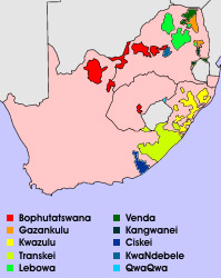
Source: Wikipedia (D)
for a big map: click here
(Source: Library of Congress)
Area: 2.857 square miles
Inhabitants: 803.806 (1992), mostly Shangana
Density of Population: 281 inh./sq.mi.
Capital: Giyani, 25.954 inh. (2011)
Languages: Shangana, English, Afrikaans
Currency: 1 Rand (R) = 100 Cents
Time Zone: GMT + 2 h
Source: Wikipedia (D)
1971 · establishment of the homeland "Machangana" (from 1973 "Gazankulu") for Shangana
1973 · South Africa grants autonomy
27th of April 1994 · new constitution for South Africa, official abolition of the racial segregation, dissolution of the homelands
Source: Wikipedia (D),
World Statesmen
The homeland was named first "Machangana", by the name of the Bantu tribe of his inhabitants. Later it was renamed in "Gazankulu" to honour a great chief, according to other sources to honour the ols Kingdom of "Gaza".
Source: Wikipedia (D)

Kindly supported by: Ralf Fischer (D)